1/2


zamiaDroid
1K+ดาวน์โหลด
4.5MBขนาด
2.7.3(12-03-2020)เวอร์ชั่นล่าสุด
รายละเอียดรีวิวเวอร์ชั่นข้อมูล
1/2
คำอธิบายของzamiaDroid
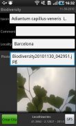
This program helps us to register geo-data using forms. It's possible to insert text data (simple or indexed in thesaurus), polygons and photos. Thanks to that we can create projects with customized fields. In addition, it's possible to import and export data to spreadsheets and databases. Data can be edited and showed in maps.
โปรแกรมนี้ช่วยให้เราได้ลงทะเบียนทางภูมิศาสตร์ข้อมูลโดยใช้รูปแบบ มันเป็นไปได้ที่จะแทรกข้อมูลที่เป็นข้อความ (ง่ายหรือจัดทำดัชนีในพจนานุกรม), รูปหลายเหลี่ยมและรูปถ่าย ขอขอบคุณที่ให้เราสามารถสร้างโครงการที่มีเขตข้อมูลที่กำหนดเอง นอกจากนี้ก็เป็นไปได้ที่จะนำเข้าและส่งออกข้อมูลไปยังกระดาษคำนวณและฐานข้อมูล ข้อมูลสามารถแก้ไขและแสดงให้เห็นในแผนที่
zamiaDroid - ข้อมูล APK
เวอร์ชั่น APK: 2.7.3แพ็คเกจ: uni.projecteชื่อ: zamiaDroidขนาด: 4.5 MBดาวน์โหลด: 45เวอร์ชั่น : 2.7.3วันที่ปล่อย: 2020-03-12 18:43:36หน้าจอขั้นต่ำ: SMALLCPU ที่รองรับ:
ID ของแพคเกจ: uni.projecteลายเซ็น SHA1: 0B:52:CA:25:07:38:DC:3C:D0:9F:B4:CD:C7:10:2D:7D:26:9D:44:65นักพัฒนา (CN): David Mart? Pinoองค์กร (O): Universitat de Barcelonaท้องถิ่น (L): Barcelonaประเทศ (C): caรัฐ/เมือง (ST): CataloniaID ของแพคเกจ: uni.projecteลายเซ็น SHA1: 0B:52:CA:25:07:38:DC:3C:D0:9F:B4:CD:C7:10:2D:7D:26:9D:44:65นักพัฒนา (CN): David Mart? Pinoองค์กร (O): Universitat de Barcelonaท้องถิ่น (L): Barcelonaประเทศ (C): caรัฐ/เมือง (ST): Catalonia
เวอร์ชั่นล่าสุดของzamiaDroid
2.7.3
12/3/202045 ดาวน์โหลด4.5 MB ขนาด
เวอร์ชั่นอื่น
2.5.9
25/3/201845 ดาวน์โหลด2 MB ขนาด


แอปในประเภทเดียวกัน


English


